

I have been working on producing high end 3D Geospatially correct images on the Howson Range/Burnie Lakes area. Using digital elevation data from Natural Resources Canada I wanted to see what I could come up with. Above is a referencing from Goggle Earth of the area I analyzed with respect to Houston and Smithers. Below is a 3D clipping from Google Earth of the general area I targeted.


(Burnie Lakes & Howson Range from 3000m)
After many hours/days of investigation including using ESRI's ArcGIS/ArcScene I came to find that there are some fantastic OpenSource alternatives that render some pretty nice results.

(View from Burnie Lake as Sun downs)
While there is no true substitute for actually being there, through the use of todays powerful processors and the tremendous amounts of programming/debugging hours of OpenSource programers, it is visually becoming ... closer

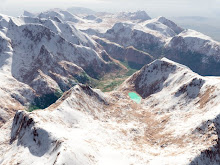
(View with camera sitting on summit of Howson Peak 2759m)
2 comments:
just beautiful!
A worthy project Mars!
Post a Comment